Bernina Pass
The long, gentle glacier-and-railway climb from the Engadin to 2,328 m
Overview
The Bernina Pass is the great high-road of the Engadin: a long, steady climb from the lake-dotted valley floor near Pontresina up to 2,328 m, run alongside the Morteratsch glacier and the tracks of the UNESCO-listed Rhaetian Railway, whose little red trains climb the same grade beside you. What makes it special is not the difficulty (it is one of the gentlest big passes in the Alps, rarely tipping past single digits) but the scale and the scenery: glacier tongues, the milky Lago Bianco at the top, and the sense of a genuine border crossing, as the road crests and drops away into Italy toward Tirano. It is a climb to settle into and enjoy.
Key info:
- Total distance: 18.1 km
- Area: Engadin / Val Poschiavo (Pontresina–Tirano)
- Recommended for: Intermediate
- Appeal: A long, gentle high-alpine pass alongside the Morteratsch glacier and the UNESCO-listed Rhaetian Railway, connecting Switzerland to Italy.
- Water & fuel: There is a tap by the base of the gondola on the approach and a fountain on the left of the first switchback; after that there is only a restaurant on the way up and another at the top
- Time of year: June–October
- Road: Well-paved, wide two-lane through-road, shared with cars, buses and motorbikes; gets busy during the day
Ascent
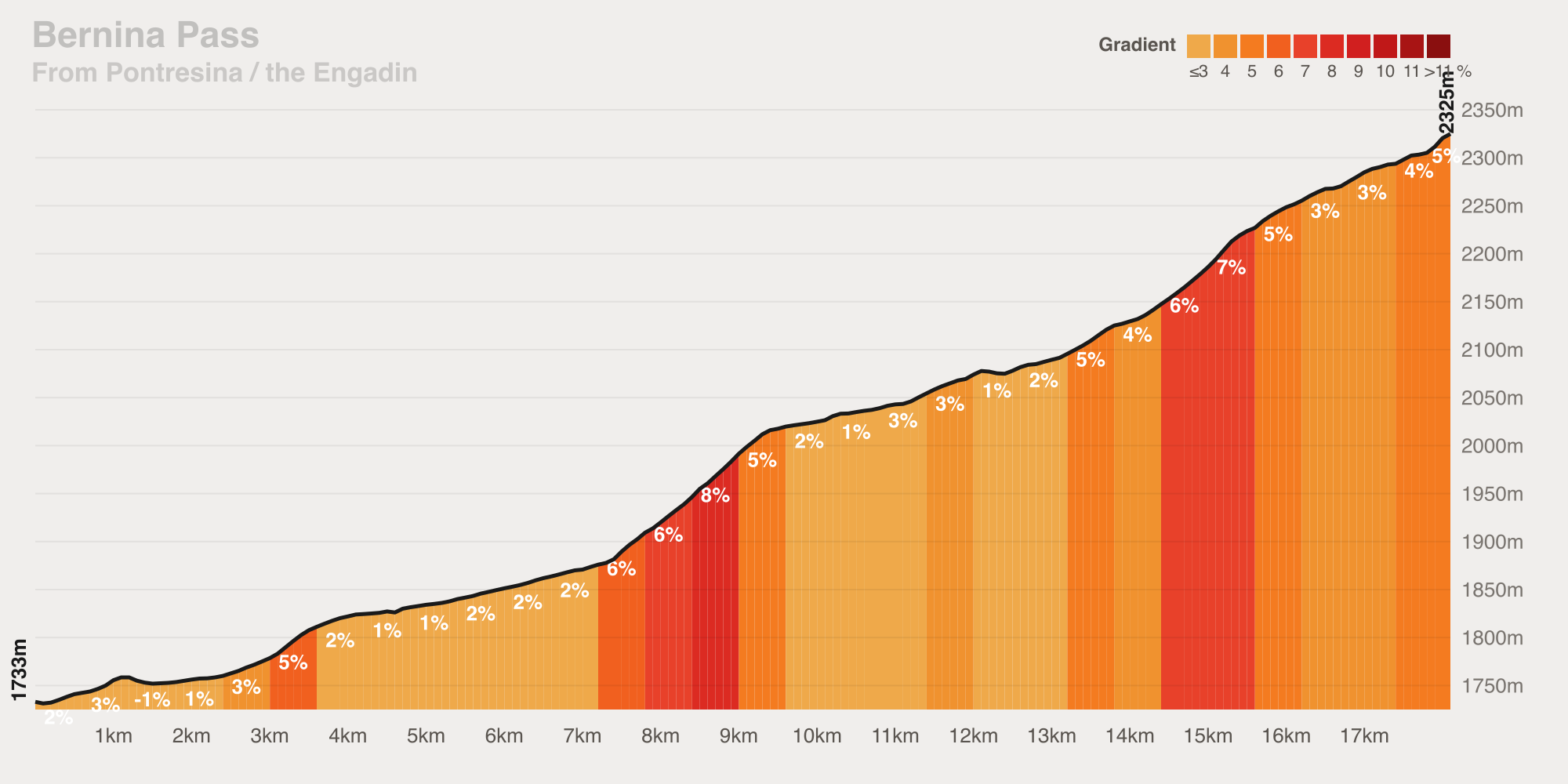
From the Engadin floor the road climbs 604 m over 18.1 km at a gentle 3.3% average — a long, honest gradient that rarely bites. The climb runs beside the Morteratsch glacier and the Rhaetian Railway, stepping up in gentle ramps, maxing out around 10%. Having ridden it twice now, the one thing worth planning is timing: go early. The road is completely shadeless and it carries a steady stream of traffic. It is not too bad but the time I did it in the early morning was far more pleasant. The summit is nice but the views are best enjoyed on the way up. If you are thinking of stopping for food consider the restaurant on the way up as the views may be better. Or wait until you are in Italy — because who does not love pizza and pasta.
Stats:
- Level: Intermediate
- Distance: 18.1 km
- Elevation gain: 604 m
- Maximum gradient: 10%
- Average gradient: 3.3%
- Estimated time (at level): 43 min
Descent
From the col you have around 32 km for descending to look forward to. Losing some 1,850 m toward Poschiavo and on down the Val Poschiavo to Tirano, at an average near 5.7% and touching around 10% on the steeper pitches. It's a long, fast, scenic descent through the Italian-speaking valley on the same wide, well-paved road, with roughly 8 hairpins and open sightlines for most of its length. The one caution is the same traffic that dogs the climb: keep an eye out for buses and motorbikes on the faster straights.
Stats:
- Level: Intermediate
- Hairpins: 8
- Maximum gradient: 10%
- Average gradient: 5.7%
Climb Profile
A gentle, stepped climb from the Engadin floor running beside the Morteratsch glacier and the Rhaetian Railway past the Lago Bianco to the 2,328 m col: 18.1 km of gain at a steady 3.3% average, ramping to around 10% on the steepest pitches.